

Thinking about land measurements can feel like navigating a whole new world, especially with the variety of units thrown around. It’s easy to get lost in the acres, bighas, and square feet. So, let’s break down some common land area measurement units, particularly with a focus on those used in India. Understanding these terms can be incredibly helpful, whether you’re investing in property, planning construction, or simply trying to make sense of land records.

Understanding Common Land Area Measurement Units

Let’s start with some of the more frequently encountered units. The square foot is a fundamental unit, representing a square measuring one foot on each side. It’s a straightforward and widely understood measurement, often used for smaller plots and individual property measurements. Then there’s the square meter, the metric equivalent, offering a similar level of granularity for those accustomed to the metric system.
Moving up in scale, we encounter the acre. An acre is a larger unit, equivalent to 43,560 square feet. Historically, an acre was understood as the amount of land a yoke of oxen could plow in a day. Today, it remains a standard measure, particularly in Western countries and is useful for measuring larger plots of land, farms, and agricultural areas. Thinking about it, an acre is roughly the size of a football field (excluding the end zones). Another related unit is the hectare, which is equal to 2.47 acres. Hectares are especially useful in countries using the metric system for agricultural and forestry land assessments.
Now, let’s dive into some units more specific to the Indian context. The bigha is a traditional unit of land measurement common in many parts of India, but its size varies significantly from state to state. This variation can be a source of confusion, so it’s essential to know the local bigha measurement for the specific region you’re dealing with. In some states, a bigha might be relatively small, while in others, it can be quite large.
Another frequently encountered unit is the katha. Similar to the bigha, the katha’s size also varies. It is commonly used in eastern parts of India, like West Bengal and Assam. One katha is substantially smaller than a bigha, making it suitable for measuring smaller land parcels or individual plots within a larger property. Then there’s the ground, a unit predominantly used in South India, particularly in Tamil Nadu. One ground is typically equivalent to 2,400 square feet, providing a convenient measure for residential plots and smaller commercial spaces.
Beyond these, you might also come across units like the guntha, commonly used in Maharashtra and neighboring regions. A guntha is approximately 1,089 square feet or 1/40th of an acre. It’s often used in agricultural contexts, defining smaller land holdings. The ankadam is another unit, primarily used in some parts of Andhra Pradesh, though it’s less common than other units on this list.
Calculating Land Area at a Site: A Practical Approach
So, how do you actually calculate land area at a site? Whether you are planning for a construction project, agricultural use, or simply want to know the size of your property, accurate land measurement is crucial. The methods used will depend on the shape of the land. Let’s walk through some common scenarios.
Regular Shapes: If the land is a simple rectangle or square, the process is straightforward. Simply measure the length and width of the land. For a rectangle, the area is calculated as length multiplied by width (Area = Length x Width). For a square, since all sides are equal, you only need to measure one side and square it (Area = Side x Side). Be sure to use consistent units throughout your calculation – for instance, if you measure in feet, your answer will be in square feet. Converting to other units like acres or hectares is then a simple multiplication or division using the appropriate conversion factors.
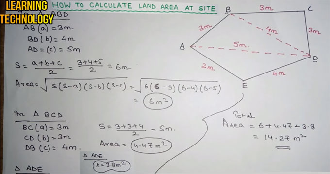
Triangular Shapes: For triangular plots, the area is calculated as half the base multiplied by the height (Area = 0.5 x Base x Height). The base is one side of the triangle, and the height is the perpendicular distance from the base to the opposite vertex. Identifying the base and height accurately is essential for a correct calculation. If you know the lengths of all three sides but not the height, you can use Heron’s formula. Heron’s formula states that Area = √(s(s-a)(s-b)(s-c)), where a, b, and c are the lengths of the sides, and s is the semi-perimeter (s = (a+b+c)/2).
Irregular Shapes: Things get more complicated with irregular shapes. One approach is to divide the land into simpler shapes like rectangles, triangles, and trapezoids. Calculate the area of each of these smaller shapes and then add them together to get the total area. The accuracy of this method depends on how well you can divide the irregular shape into regular components.
Another method for irregular shapes is to use surveying techniques. A land surveyor can use tools like GPS devices, total stations, or laser scanners to accurately map the boundaries of the land. These tools can provide precise measurements and calculate the area using specialized software. While this method is more accurate, it also tends to be more expensive.
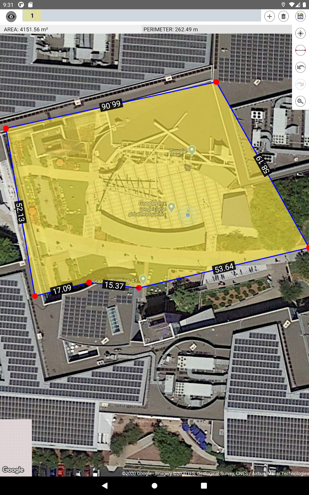
A more approximate, yet accessible method involves using online mapping tools like Google Earth. You can trace the boundaries of the land on the map and use the built-in area measurement tools to get an estimate. Keep in mind that the accuracy of this method depends on the resolution of the satellite imagery and the precision of your tracing.
Considerations for Sloping Land: It’s important to note that these calculations assume a flat surface. If the land is sloped, the actual surface area will be larger than the area calculated using horizontal measurements. For highly accurate measurements on sloping land, you would need to account for the slope angle. Surveying instruments can measure the slope and calculate the surface area accordingly.
Finally, regardless of the method you use, it’s always a good idea to verify your measurements. Double-check your calculations and, if possible, compare your results with existing land records or property surveys. When dealing with property transactions or legal matters, consulting with a qualified surveyor or legal professional is always recommended to ensure accuracy and compliance with local regulations.
In conclusion, understanding land measurement units and knowing how to calculate land area are invaluable skills. While the specific units and methods may vary, the underlying principles remain the same. Whether you’re dealing with acres or bighas, rectangles or irregular shapes, accurate land measurement helps ensure fair transactions, effective planning, and a clearer understanding of the land beneath your feet.
If you are searching about Land Area | PDF you’ve came to the right place. We have 5 Pics about Land Area | PDF like Land Area | PDF, Common Land Area Measurement Units in India: A Guide – TimesProperty and also Land Area | PDF. Here you go:
Land Area | PDF

www.scribd.com
Land Area

thailand.go.th
Common Land Area Measurement Units In India: A Guide – TimesProperty
timesproperty.com
How To Calculate Land Area At Site – Engineering Feed
engineeringfeed.com
land area calculate how site teach useful learning construction technology another he presentation will video
Easy Area : Land Area Measure For Android – Download
easy-area-land-area-measure.en.softonic.com
Land area calculate how site teach useful learning construction technology another he presentation will video. Land area. How to calculate land area at site – engineering feed
Gallery for area of land Land area


